Sunday, November 28, 2010

Desierto Central

The forecast was calling for more rain along the northern Baja coast.  We decided that we wanted to get to the warmer and drier southern areas a bit quicker.

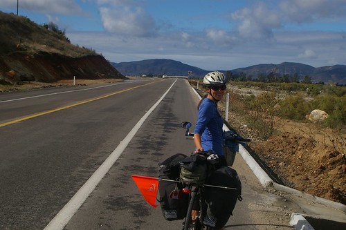
So, after cycling for over 3,000 kilometers and across two borders we put our bikes on a bus.

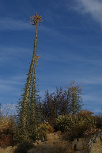
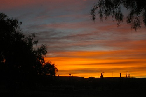
Our first destination by bus was Cataviña.  From the bus stop we cycled two kilometers south of town to camp at Rancho Santa Inés (25 pesos per bike, less than $2.50 each).  Karen built a mesquite campfire using what was lying around.  The desert has some amazing smells.  We watched a colourful sunset and then the full moon rise over the desert landscape with its unusual cacti, called cirio, that looks like something out of a Dr. Suess book.

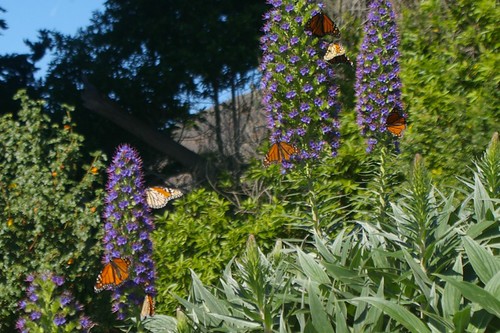
We spent the next morning exploring the desert around our camp.  There are an amazing variety of cacti and other desert plants including some found only in the Baja peninsula.  The Cirio is described as an upside down carrot.
IMGP5829.JPG

Back in the village of Cataviña a homeless American regaled us with tall tales of his life as a child actor (the movie Tarzan, he was the boy), opening up a brewery when he was five, being advised by Marilyn Monroe and Mae West on property investment, and writing songs for Elvis, John Lennon, the Beach Boys, etc.  We had our fair share of experiences with people suffering from mental illness in towns and campgrounds along the US Coast.  There were men at the hike/bike sites who ranted to themselves all night in their tents. So much so, you'd think there were two people having an argument.  And the fellow in Carpinteria who spoke philosophically about society, reality and the animated film playing in his head that one day he'll make except he's been getting into trouble with copyright. 

But hadn't expected to run into someone like this in a small Mexican village.   

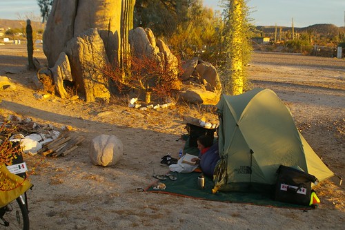
After enjoying another colourful sunset we slept again beneath the clear desert sky.
IMGP5835.JPG
IMGP5840.JPG

The 7 AM bus arrived at  8 AM.  While waiting we watched the American homeless man set up in front of the main store and beg for pesos from the Mexican truck drivers.  The man selling diesel and gasoline from drums along the side of the highway saw the bus first and helped us flag it down.  The bus took us past the 28th parallel into the state of Baja California Sur.  Next stop, San Ignacio.

Saturday, November 27, 2010

Ensenada

date = 2010-11-21
distance = 43

IMGP5797.JPG

Our second day in Mexico was much more pleasant. Since we were on the "ruta del vino" we decided to do a wine tasting along the way and had a fun conversation with Ricardo, the wine server. The wines were good. The Mision de Guadalupe wine "uvas" have been grown there, and the wine processed, bottled, and consumed there for the last 50 years.

Highway 3 through Valle de Guadalupe was recently paved and had a wide shoulder so it was great for cycling. As it approached Ensenada the shoulder narrowed but the highway became four lanes so that gave passing vehicles plenty of room. We did see other cyclists out on this stretch of highway - a couple of mountain bikes and several Mexican roadies.

We spent the night at a hotel in Ensenada after a walk around town sampling the local wares: cooked corn smothered with butter, mayonnaise and cheese, churros, fish tacos and cervezas.

Sunday, November 21, 2010

La Frontera

date = 2010-11-20
distance = 89.5

We had camped just north of the border planning to cross early in the day and make it as far away from the border zone as possible by the evening.  But with a storm approaching we started our day uncertain whether or not we would stay in Tecate, the border town.

The border crossing itself proved confusing.  We actually crossed the border without being stopped and then had to turn around and find the immigration office to get our passports stamped.  The whole process was much more laid back than entering either the US or Canada.

Although we had encountered light rain on the way to Tecate it had now stopped and the sky was looking clear to the south.   We decided to continue our ride rather than stay in a Tecate hotel.

This was our first day in Mexico and we were expecting warmth and sunshine.  Instead we faced a cool and wet day.  At first the rain showers were intermittent but by afternoon it was a steady downpour that was heavy at times.

The weather alone would have made the riding uncomfortable but we also discovered that for 25 kilometers out of Tecate the highway was under construction.   There were sections of new pavement where the highway was wide and smooth.  But there were also long stretches where it was just a dirt road with a little gravel.  The only consolation being that because the road was so rough the other traffic was forced to drive slowly.

To make things more difficult we were cycling through mountains which meant climbing more hills.

So conditions couldn't get any worse.

Unless we also faced a strong headwind for most of the day.  Which we did.

It took considerably longer than expected to complete the day's ride.  On the brighter side the traffic on highway 3 was light and we were waved through our first military checkpoint with no questions asked.

We had planned to camp at Rancho Sordo Mudo but we arrived soaked and there were no other campers at the lonely site so we cycled a few more kilometers to the town of Francisco Zarco.  With night falling we wanted to be sure we could find a dry place to stay.  Karen used her Spanish to get directions from a local shopkeeper.  The shopkeeper offered her home as a backup place to stay if we couldn't find the cabañas for rent.  But her directions proved accurate and we settled into a simple but elegant cabaña for the night.


Potrero

date = 2010-11-19
distance = 63.12

Our last day in the USA and day 47 of our trip. Rob reports that we
climbed 3000 feet this day with the most elevation gain in one day. We
left San Diego after breakfast and a flat tire repair at Ann and Brad's.
We headed for the hills to stage our approach to Mexico through Tecate,
a smaller, quieter and safer border town than Tijuana. Along our route
was a border patrol checkpoint for traffic travelling west, and an
entourage of border control vehicles passing us at least every 15
minutes. At the bottom of one of the hills we passed the turnoff to
Tecate, where we would come back in the morning (exciting!) and climbed
up to Potrero county park to set up camp.

Brad had warned us of the storm coming. It was expected to start raining
that evening. The rain didn't come but there were some cold temperatures
in them there hills.

Luckily, we met the kindness of Moe and Ian, a couple from Toronto that
are driving their windsurfers, kayaks, stand-up-paddle boards and
bicycles to Baja del Sur. They'll spend three months at La Ventana
amidst like-minded adventurers (and maybe us when we make it that far).
They welcomed us into their warm RV for dinner where we ate and drank
and talked about travels and the road ahead. A perfect send off to Baja
California, Mexico! Here we come!

San Diego

date = 2010-11-18
distance = 68.9

Not so sure when L.A. ended and San Diego began but somewhere in the middle, and our morning coffee stop, was Ensinata. A nice roadside beach town with lots of yoga studios and a lighthearted feel to it, boding well for what was to come in San Diego. We had a conversation
with a man that had walked from Eugene, Oregon a ways south as a protest against the BP oil spill. He'd been given a bike at some point and we talked about how fast it is compared to walking. Much faster.

We'd planned for a short riding day into San Diego so we could do one last equipment shop at REI and wrap up other such errands. By lunchtime we were mired in the roads and highways of the big city. At REI we bought a UV water purifier (which Rob is quite happy about, I can tell), received warnings about Mexico amidst encouragement from others, and an
offer to stay at an employee's home. But we were all set up with a warm shower (www.warmshowers.org) by hosts Ann and Brad and to thither we made our way.

San Diego proved difficult to ride through. It was nice ending the day in a comfortable home where we were treated to dinner, showers, interesting conversation and a good night's sleep. The rooster on the other side of the street didn't even wake us up. (We have noticed
numerous urban roosters since L.A., and I have to say I love them).

Note from Rob - I am not so sure the UV water purifier was a necessary purchase even though it is a fun toy. And I thought San Diego was more bike friendly than LA with only one major route finding problem.

IMGP5793.JPG

Huntington Beach to South Carlsbad

date = 2010-11-17
distance = 109.16

by Karen

After a coffee break in Huntington Beach, replete with congratulatory
greetings from some locals we continued on. Not much to say here but
that we were riding in a continuous stream of traffic through the
communities that line the coast the entire day. Our guidebook indicated
that we would be riding through a section of countryside but Rob and I
both managed to miss it. We did find refuge at Crystal Cove State Beach
where we enjoyed another lunch by the sea.

We rode through the nice looking town of Carlsbad during sunset, which
was around 5pm, and rolled into South Carlsbad campsite near dark. These
short days are keeping us on our toes. Unfortunately South Carlsbad
doesn't have hiker/biker rates (as our guidebook suggests) and the
rangers wouldn't budge on the full camping rate for us cyclists arriving
after dark. We opted to pay it rather than ride 7 miles further to San
Elijo and noted how we were
in the more conservative county of Orange.

Burbank to Huntington Beach

date = 2010-10-05
distance = 84.8

Karen joined Sommer at yoga class in the morning while I worked on
fixing a corrupt folder in my email storage (which explains the backlog
in blog posts and emails).

After saying good bye to Rich, Sommer and Hudson (the dog) we rode to
the nearest Metro station to try out the LA public transit experience.
We had opted to take the rail line under Hollywood hills rather than
riding the busy streets over them again.

At Hollywood and Vine we got back on our bikes and began the process of
trying to find a good route through the city. After a few wrong turns
we eventually reached one of the "rivers" that flows through LA. The
"river" has been formed into a concrete channel with a separated bike
path along the side. It proved challenging to find an entry point to
this bike path but once located it provided a peaceful and fast route
back to the beach.

After some more great beach riding we rejoined highway one which had
become a very busy four lane street with no shoulder and frequent
traffic lights. We wished that we had allocated more time for this section.

We eventually arrived in Huntington Beach where we had booked a hotel
due to the lack of camping along this section.

Los Angeles

date = 2010-11-15
distance = 81.1

The day began with a ride through the long city of Malibu. We were
surprised to hear one of Karen's favorite sounds, a rooster crowing,
coming from one of the palatial estates overlooking the highway.

In Santa Monica the fabulous bike route which winds its way along most
of LA's beaches began. We stopped for Gelato at Venice beach and then
turned inland.

At this point we were deviating from our guide book. And we were
entering LA where the car is still king of the road. I had downloaded a
bike map of the area and plotted out a general path to take but there
were many gaps between bike paths and designated bike routes.

I had also hoped to get a paper version of the map which would be easier
to read as we rode. But everyone at the bike shops and tourist info
centres seemed dumbfounded by the idea that anyone would want to ride a
bike anywhere but the beach.

The first part of our trip went well. We followed an adequate but
somewhat variable bike lane along Venice Boulevard and then took side
streets through Hollywood. We stopped briefly to look at the tourist
trap of Hollywood Boulevard. The next section was the one I was most
concerned about which involved getting over the Hollywood hills. The
hill itself proved to be less difficult than others we have done. And
the streets along the 101 freeway turned out to be a good route until we
arrived at the fast, busy and shoulder-less street leading into Burbank.

That night we stayed at Sommer and Rich's place in Burbank. They served
us one of the best meals of our entire trip and then took us up to
Griffith Observatory for a 360 degree view of the city. After that it
was to a cool little establishment in Burbank that serves a wide variety
of California microbrews (the whole micro-brew thing seems like a theme
for this trip). And then a comfortable night's sleep in a real home for
the first time in 40 days.
IMGP5788 (Modified).JPG

Carpinteria to Leo Carrillo

date = 2010-11-14
distance = 77

Just another typical day of cycling in Southern California. Lunch
outside yet another historic mission, this time in Ventura. More
farmland growing fruits and vegetables for our supermarkets.

Spent the night at Leo Carrillo campground on the edge of LA county and
had dinner on the beach watching surfers.

Santa Barbara and Carpinteria

date = 2010-11-12
distance = 55

In the morning we stopped at a bike shop (Bob's Bikes) in Goleta, just
before Santa Barbara. I had noticed one of my tires getting low on air
and when I went to pump it up at the shop it burst. So we fixed our
first flat of the trip.

The bike shop staff member gave us some good advice about bike routes
and shopping so we ignored the book and followed some of Santa Barbara's
bike routes. Taking his suggestion we stopped at the Isla Vista food
co-op to stock up on groceries and ate lunch there as well. It had a
nice community feel to it. While eating lunch we got talking to a
farmer who seemed to know everyone - the staff, the construction guy and
delivery truck driver.

For the next 20 miles we rode a great bike route mostly separated from
the traffic. And we saw more bikes than we had seen anywhere else. The
route took us through the UCSB campus where there were several massive
bike parking areas that looked like something from Amsterdam or Copenhagen.
IMGP5775.JPG

We did a side trip to the historic mission area of Santa Barbara and the
quaint (but somewhat upscale) downtown shopping area.

That night we camped at Carpinteria State Beach. They only allow bikers
to camp one night and we wanted to take a day off there so we paid full
price for a regular camping spot for the second night.

We spent our day off catching up on emails in a coffee shop, doing
laundry, sitting on the beach and drinking great beer at a strange
micro-brewery bar.

Note to users of the "Bicycling the Pacific Coast": The book suggests a
bike path between Refugio and El Capitan beaches. The bike path is
closed and blocked by gates in a middle section. You can get your bike
around the gates but it requires dismounting and lifting your bike.

Thursday, November 18, 2010

Oceano to Refugio

date = 2010-11-11
distance = 113

This day began with riding country roads through farmland and towns with
a distinctive Spanish language influence. We saw many farm workers out
in the field and enjoyed hearing the Mexican music that was blasting
from the trucks (nothing like a little accordion music for cycling).

At over one hundred kilometers this was one of the longest days we had
done in weeks. But we made it to the campground in good time despite
one change in the route along the way.

The campground, Refugio State Beach, turned out to be Karen's favorite
so far. The biker site was right beside the beach and we camped under
palm trees.

Note to users of "Bicycling the Pacific Coast" - Harris Grade road which
is part of the suggested route is closed through January 2011. Use
highway one for this section instead.

IMGP5773.JPG

SLO (San Simeon to Oceano)

date = 2010-11-10
distance = 94

Today we stopped for morning coffee and grocery shopping in Cambria.
Lunch was on the plaza outside the historic mission in San Luis
Obispo. Although the outskirts of the city seemed like generic strip
mall Americana, the downtown turned out to be rather pleasant.

Our destination for the evening was Oceano Campground which turned out
to be no longer accepting bikers. But the swiss couple had already
convinced the ranger to let them stay and have us join them.
IMGP5752.JPG
IMGP5759.JPG

Kirk Creek to San Simeon

date = 2010-11-09
distance = 64.4

Today was our last day in the area known as Big Sur. The route
flattened out for the second half of the day and we rode by a big
Hereford ranch that stretched for miles.

The highlight of the day was stopping at a beach that is an elephant
seal resting place. The adult males and females were mostly out at sea
but we saw juveniles which were certainly large enough.

IMGP5761.JPG
They appeared to be quite lazy just lying about with the occasional
scratching motion. But a guide at the park explained that the seals
take feeding trips up to the ocean off Alaska (in about 3-4 weeks thus
traveling faster than us). When they return to this beach they rest and
their body actually converts the fat that they have accumulated to
muscle. Too bad we couldn't do that by just laying around!

We skipped Hearst Castle, the more popular tourist site along this
stretch. We spent the night, along with several other cyclists, at San
Simeon campground.

Wednesday, November 17, 2010

Big Sur Inn to Kirk Creek Campground

date = 2010-11-08
distance = 38.8

Our third day on the Big Sur coast dawned sunny - a welcome relief. We
enjoyed more stunning coast along twisting, rolling and narrow
highways. Lunch was at Julia Pfeiffer Burns Park. We stopped at a
one-store town in the afternoon looking for groceries (which proved hard
to come by along this stretch). Another traveler who had stopped there
got talking to us and it turned out she had spent time in Vancouver
working with the early Greenpeacers (Rex Weyler et al).

We camped that night at Kirk Creek along with the Swiss couple.
IMGP5741.JPG

Sunday, November 14, 2010

Big Sur

date = 2010-11-07
distance = 12.9

by Karen

So, what's the big deal about Big Sur? I didn't know until now, but now
I think I get it. Big Sur is an eighty mile coastal area extending from
Carmel south. It's dotted with amenities like bakeries and galleries
tucked into the redwoods between glimpes of the ocean. Glimpses to us,
because it was all fogged over today. A fellow cycle tourist advised us
to take in the area as it's the untouched coastline of central
California. In my head I'm thinking of all the wildness that is BC.
But they certainly do have something special going on here.

About every 2 miles after we left our campsite there was something
intriguing about the roadside stops. They hinted at the character of
the place. Out of desire to make way, you just can't stop everywhere,
and having made a late start from the campsite we bypassed the bakery
and the Henry Miller memorial library. But by the time we reached the
Coast Gallery which boasts a cafe atop a retrofitted water tank the rain
was coming down and visibility along this already treacherous roadway
wasn't good. After lunch and seeing the weather worsen we were prodded
by the gallery owner to stay off the road. We agreed it would be wise
not to continue south and to cycle 2 miles back to the closest inn.

Well, here we are in the Franklin room of Deetjen's Big Sur Inn. This
place is steeped in history and quality and serenity. The cabins are
handcrafted with scavenged redwood by a Norwegian with great foresight.
He built it in the 1930's before Hwy 1 was even built. Photographs of
who I think is Jack Kerouac line the dining room walls. The local paper
advises that Big Sur is a place to do nothing. And past transients have
written their personal stories of restoration in the Franklin room
journal. We've been milling about our spacious room with fireplace
drinking wine and had a well crafted meal in the restaurant. We are so
lucky to be able to treat ourselves to a stay here on this rainy day.
What a find.

IMGP5726.JPG
[photo in front of our room the next morning when the storm had cleared]

Saturday, November 13, 2010

Carmel

date = 2010-11-06
distance = 51.7

by Karen

We aspired to another short day. The guidebook suggests a 60 mile ride
along this hilly and cliff hugging section of Hwy 1, or two 30 mile days
so one might enjoy Carmel and what's to enjoy of Big Sur. We chose the
latter. We set out in good time after a brief chat with a Swiss couple
who will also be riding through Baja. It's nice to know there will be
other cyclists on the road.

Up and over the hill, we arrived at the Hwy 1 gate where cars pay a
$9.50 toll to drive the 17 mile road. We bypassed this section, which
involves more hills (and not to mention 17 additional miles) with some
spectacular mansions and estates. We spent the morning in Carmel. I
with a cappuccino gleaning a local magazine for news about town while
Rob had an americano. Clint Eastwood used to be mayor of this town.
According to the magazine, him and his wife continue to be active
community members when not attending the many gala gala do's required of
a Hollywood couple, such as the Toronto Film Festival.

Carmel is blocks and blocks of small stout adobe houses surrounding an
upscale commercial district along Ocean Drive. It's interesting
approaching these ritzy places as bike touring budget travelers.
Walking into coffee houses wearing full rain gear, including shoe covers
whilst others are adorned with fall colour sweaters and wraps. Using,
and forgetting there, the spoon that makes up part of Rob's camping
utensil set to sop up cappuccino foam. Not even considering clothes
shopping because the paniers are at capacity.

After a short setback to retrieve the camp spoon we sailed past the
Carmel Mission and back onto the highway. We stopped at a beach down
the road for lunch: cooked lentils, chevre, a red pepper, walnut and
pomegranate pesto and salad greens wrapped in tortilla. Fighting a
headwind and a little disappointed to have cloudiness over what is
supposed to be a very scenic ride we headed into our campsite at the
Pfeiffer-Big Sur state park. Another dark hiker/biker site amongst
redwoods where we set up tent atop Eucalyptus leaves and ate some
camping fare by candlelight.
IMGP5721.JPG

Sunday, November 7, 2010

Santa Cruz to Monterey

date = 2010-11-04
distance = 65.6

We set out for a short cycle to Monterey where we definitely wanted to
stop and see the town. Yay! Short cycle day followed by a day off.
Somehow these short cycle days don't get us to our destination much
faster. We fill the day with things like a leisurely egg breakfast at
Farm Cafe just miles from New Brighton beach state park. Yum! Another
stop at a grocery store and we were on our way.

The ride was nice and easy but for a bit of a headwind and hot hot sun.
We passed many farms, farm machinery and farmworkers at work, the scent
of strawberries in the air. Some of the machinery covered the fields in
plastic with the seed drills coming along behind them. Fields of
plastic. I hadn't considered such a thing before. I have seen it used
before as a mulch to keep the weeds down but I hadn't considered it on
such a large scale.

The latter part of the ride was on bike paths along busy roads and
through dunes in Marina, Seaside and then Monterey. We stayed at the
Veterans Memorial city park which turned out to be atop a steep hill and
beside the Presidio. Even after such a short riding day we couldn't
face going down the hill to see more of Monterey only to come back up
again. Plus, there were plenty of other cyclists to share stories
with. One fellow from Germany, the aforementioned cyclist going to the
tip of South America having started in Alaska.

Soldiers at the Presidio graced us with a gorgeous rendition of taps on
the bugle and we were off to sleep.

Our day off in Monterey had us enjoy Americanos in the East Village
cafe, a walk through Cannery Row, a visit to the Aquarium, cycling along
a superb bike pathway out to Lover's Point, then back to visit the
Mission, an old adobe structure. One of many that we'll be seeing from
here on in.

Half Moon Bay to New Brighton Beach (Santa Cruz)

date = 2010-10-03
distance = 90.9

by Karen

Up and at 'em, we ate our granola packed up and moved on. Our guidebook
suggested a stop at Ano Nuevo park and we obliged. The park ranger
informed us there was a guy a day ahead of us making his way to
Patagonia. Hmmmm. Up until now we hadn't met any other cyclists going
south of the border. After lunch in some scorching hot sun and
listening to the elephant seals barking in the distance we pressed on.

Dreaming of ice cream we happened upon an organic farm that enticed us
with their "10% cyclist discount" sign. And we were glad they did.
Swanton farm is the oldest organically certified strawberry farm in
California. They had a whole farm store/ lounge area replete with
couches (oh, to sit on a couch!) full of interesting reading material
and all on the honour system. We tallied up our purchases: broccoli for
dinner, strawberries for dessert and ollalieberry shortcake for now!
Articles on the wall talked about the history of the farm and the
unionized farm workers. Their slogan: "si se puede".

We ended the day with a ride along West and then East Cliff road through
Santa Cruz. They have a stunning waterfront with gorgeous houses,
interrupted by "the boardwalk", an amusement park that had shut down for
the season. All along the coast people were out walking, running,
cycling, surfing or watching the surfers. Some surfers rode their bikes
one-handed with their surf board tucked under their other arm. Later we
learned Santa Cruz had seen a big swell this week so surfers were out in
droves.

New Brighton Beach had a nice biker site where Rob cooked up quinoa,
farm fresh broccoli and cashews for dinner. Fresh in-season
strawberries for dessert, delicious!

San Francisco to Half Moon Bay

date = 2010-11-02
distance = 42.8

by Karen

We leisurely departed San Francisco and our comfortable room at the
downtown hostel. One last stop at REI - we'd decided silk sleeping bag
liners were a justifiable luxury for the two remaining months of our
trip. We'd started out our journey with a home assembled cotton
sleeping bag liner sewn from two old bedsheets. However, one of these
bedsheets had been deemed "old" because it had ripped down the middle. I
thought a quick zip with Jonanne's sewing machine would have done the
trick. Well, the first night into our trip the sheet began ripping in
multiple places and had steadily deteriorated into what would have made
a good mummy costume for Halloween. Not the makings of a good night's
sleep. So, silk sleeping bag liners - worth it!

The route out of San Francisco took us through Golden Gate park once
again which was lovely. Then a ride along Ocean Beach out of the city.
We stopped for groceries and lunch in Daly city and made it to Half
Moon Bay around 4pm. A nice site close to the beach, we listened to
pounding waves, enjoyed a sunset and then the stars.

IMGP5700.JPG


San Fran Day 2

date = 2010-11-01
distance = 29.7

map:
http://maps.google.com/maps/ms?ie=UTF8&hl=en&msa=0&ll=37.80185,-122.416019&spn=0.007663,0.01781&t=p&z=15&lci=bike&msid=107416974468120158737.0004945131647511ff99b


Today was a day for hitting up some San Francisco sites and shopping for
some gear that we needed. First stop was REI (the American MEC). Next
we went to the ferry building where we had coffee with Joanna, Dan and
their children. They are a family from Vancouver who also happened to
be in San Francisco.

After that we rode our bikes part way up telegraph hill. Most tourists
visit this site to get great views of the city and harbour. But we were
also hoping to catch a glimpse of the wild parrots made famous in the
documentary film that we had recently watched with Carol and Maryanne. A
vendor informed us that we were late. The parrots usually stop by early
in the morning.

We headed back down the hill for lunch at an Italian cafe in North
Beach, the little Italy neighbourhood. Tasty pasta fired us up for a
trip up and down Lombard St.

We stopped at the bottom of Lombard, one of the steepest hills in the
city. In fact the block at the crest is so steep that instead of a
straight street they have used switchbacks. The block is a popular
tourist destination - the "crooked" street.

Earlier in the day Karen had expressed a desire for a day's rest from
hard cycling so I expected we would simply gaze up at the steep street
from afar and move on. But no, Karen wanted to bike up the several
blocks of steep street.

As we approached the switchbacks on our bikes we were applauded by
tourists on foot. At least we provided some entertainment for them.

The "crooked" street section is one way. We had to carry our bikes up
the stairways that served as sidewalks. I suggested we stop half way
but Karen pressed on to the top. And then we rode the bikes down the
switchbacks.

IMGP5685.JPG

IMGP5693.JPG
After that Karen suggested we find some more hills aka "views" but she
was suddenly distracted by an interesting sound.

Could it be.....

Yes, we had found the parrots! We caught glimpses of a few of them
flying and roosting.

We went to explore the Polk Street neighbourhood and then rode down to
the civic plaza. A crowd had gathered in front of a large screen to
watch the final game of the world series.
IMGP5695.JPG

We tarried there for a short while (the score was still 0-0) and then it
was off to chase the sunset. Karen suggested watching from Twin Peaks
with another ride through the pan handle of Golden Gate park. But
partway there we decided to have ice cream and lo and behold was the Ben
and Jerry's store at Haight and Ashbury. The sun settled as we shared a
sundae in the shop window. Early evening upon us we headed part way
down "the wiggle" but veered off to the Castro for a quick dinner of
Fish Tacos (wild caught Salmon). That was where we were when the game
ended and the crowds poured into the streets.

We watched Giants fans decorate the overhead trolley lines and the
police eventually shut down the streets to cars. Then we rode back to
the hostel and spent some more time with the crowds who had also
congregated along Market Street downtown.

Friday, November 5, 2010

SP Taylor to San Francisco

date = 2010-10-31
distance = 57.3 km

IMGP5670.JPG
We left our campground in a redwood forest and headed back to dry hills and rural landscapes. But it wasn't long before we began to enter the urban zone.

Most of our tour has consisted of long stretches on the shoulder of the same highway. Not many route finding skills are required. But now we were entering an unfamiliar urban environment with complicated interconnecting bike routes that weave their way through the Bay Area cities and towns. So, I expected that we would have to pay more attention to maps, signs and our guide book's instructions. However, none of this was required. All we had to do was follow the hordes of cyclists that were coming to and from San Francisco. And I mean thousands. It seemed like half the population had decided to use the same bike route that we were using to get into the city. There were plenty of MAMILs (middle aged men in lycra) but also folks out for a more leisurely ride and even tourists on their rental bikes. Many shouted questions about our trip as they passed by and offered congratulations on what we are doing and how far we'd come. One even acted as an impromptu tour guide for part of the route.


We stopped for lunch at a cafe in Sausalito. And then rode across the Golden Gate bridge stopping to take the requisite pictures. From there we headed to Golden Gate park where we found ourselves on a major street through the park that had been closed to cars and open only to cyclists and pedestrians. This is one of San Francisco's events for "Sunday Streets" (aka Ciclovía). The City of Vancouver had talked about a similar event last year but was never able to bring it to fruition. IMGP5680.JPG

As we were leaving the park another cyclist riding along side us asked about our trip. After giving the now familiar responses of where we started and where we were going, Karen asked how to get to the hostel where we had a reservation. Once again we were offered a guided tour for part of our way there. He took us along a route known as the "wiggle." So named because it takes a somewhat circuitous path that avoids the hills between Golden Gate Park and Market Street. As we learned this was the key to cycling in San Francisco - knowing how to avoid the hills.

After unloading our luggage at the hostel we decided to take a break from cycling and walked to the Mission District. We found busy streets full of families out trick-or-treating. We decided to have dinner at an organic Mexican restaurant aptly named Gracias Madre. It wasn't until we were seated and reading the menus that we realized that it was not only organic but also vegan. Now, usually I am disappointed with vegan attempts to imitate cheese and cheese is often my favorite part of Mexican dishes. But I was not disappointed this time. The food was great (and so was the organic porter I had to drink). I do have a special fondness for Bandidas on the Drive in Vancouver (it is where Karen and I met) but they could take a lesson from this place.

After dinner we walked around the Mission district some more then rode the public transit through a few more neighbourhoods to get a feel for how people were enjoying Halloween.

Bodega Dunes to Samuel P Taylor Park

date = 2010-10-30
distance = 65.3 km

Another overcast day but only brief periods of rain.  We cycled through hilly farm country past several organic operations (mostly dairy).  We saw a couple of flocks of wild turkeys.

We are less than 30 miles from downtown San Francisco and I am surprised how much farmland and lack of "development" there is.  The small villages do seem a little more upscale though.  More yoga studios and art galleries than you would find in most of rural America.  And good espresso too  - but we have seen that almost everywhere along the coast.

We even saw some wild turkeys cross the road.
IMGP5664.JPG

We shared the hike and bike area of the campground with a group of five engineers who had biked out from San Francisco for an overnight trip. Just like in Vancouver the conversation inevitably turned to backyard chickens.  But being that we are so close to Silicon Valley the discussion centered on using home automation software to monitor and control your chicken coop.  Apparently you can have it tweet you to let you know when the chickens have roosted for the night.